Port of Miike  To a new world and future where the sky's the limit!
HOME    
Japanese ENGLISH
 
The Port of Miike Plan
 
Go to a top page
The Port of Miike
Port Plan
Recycling port
Guide to shipping routes
Description of facilities
Access and description


Government offices concerned
International container route use promotion business
 
The following presents an overview of the Port of Miike Plan.
 
The Port of Miike Port Plan
 
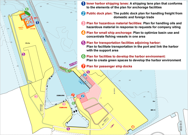
The following is an overview of the Port of Miike Plan approved at the 170th meeting of the Planning Subcommittee in the Transport Ministry's Port Deliberation Council.
(as of February 2007)
 
Inner harbor shipping lanes: A shipping lane plan that conforms to the elements of the plan for anchorage facilities
  Water depth Width
Plan -10.0m 72m
(Existing facilities) (-7.3m) (50m)
  Pier length Water depth Dock land
Existing facilities 210m(1 berth) -10m 3.9ha
Under construction 130m(1 berth) -10m 1.1ha
Plan -
130m(1 berth)
-
-7.5m
3.3ha
3.5ha
Plan for hazardous material facilities: Plan for handling oils and hazardous material in response to requests for company siting
dolphin Water depth   hazardous material facilities Area
Existing facilities -5.5m~-7.5m   Existing facilities 19.8ha
Plan for small ship anchorage: Plan to optimize basin use and concentrate fishing vessels in one area
Existing facilities Inner harbor north district small ship anchorage
Plan Yotsuyama area small ship anchorage
Plan for transportation facilities adjoining harbor: Plan to facilitate transportation in the port and link the harbor with the support area
Plan for facilities to develop the harbor environment: Plan to create green spaces to develop the harbor environment
Plan for passenger ship docks
Small wharf Number
Existing facilities 1
 
Return to Top
 

Port of Miike Tel: 0944-54-7248 Copyright (C) 2007 PORT OF MIIKE. All Rights Reserved.